Cape Three Points
Grade 3: Second and Third Points are in natural surroundings and worth visiting. Access involves some walking. Another example of Cook’s naming, for the guidance of future navigators, of distinctive headlands that were visible from well out to sea.
Situation: South east of Gosford. It is possible to visit all three points. First Point is just to the north of Tudibaring Head, Copacabana, south east of Gosford. Second Point is Mourawaring Point, and Third Point is Bombi Point. Second and Third Points are in natural surroundings in Bouddi National Park, while First Point is on the edge of suburbia at Copacabana. Captain Cook Lookout, off the high point of Del Monte Place, Copacabana, and close to First Point, is a useful viewpoint. Looking south the other two points can be seen with Sydney in the background. Using the zoom on his map shows access to both Second and Third Points in Bouddi National Park, as well as to First Point:
Coordinates (decimal): 33.50 S 151.44 E
Endeavour Journal – 7 May 1770:
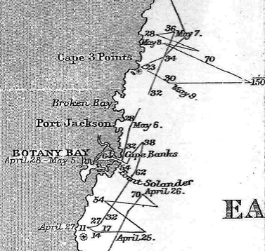
At Noon we were by observation in the Latitude of 33.22 S and about 3 Leagues from the land, the northermost part of which in sight bore N 19 East. Some pretty high land which projected out in three bluff points and occasioned my calling it Cape Three Points (Latde 33.33) bore SW distant 5 Leagues.
8 May 1770:
Our situation at Noon was nearly the same as yesterday, having advance’d not one step to the northward.
9 May 1770:
Stood in shore until 8 oClock AM and hardly fetched C. Three Points. Having little wind at NWbN we tackd and stood off until Noon… being then in the Latde of 33.37, Cape Three Points bearing NWBW distant four Leagues.
10 May 1770:
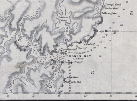
In the PM had the wind at NEbN with which we stood in shore until near 4 oClock when we tack’d in 23 fathom water being about a Mile from the land and as much to the Southward of Cape Three Points.
Northerly winds and a southerly current meant that Endeavour was further south at noon on 9 May than she had been 48 hours earlier. A few hours later the ship had moved north and was again off Cape Three Points.

Endeavour’s track in the vicinity of Cape Three Points, 7 – 10 May 1770. A reduction of Captain Cook’s original chart of the east Australian coast line 1770 from originals in British Museum, South Sheet (part). State Library of Victoria, MAPS 805.8 AJ 1770-1890.

John Lort Stokes’ 1852 Chart, Australia East Coast, Sheet IV, Broken Bay to Sugarloaf Point (part). National Library of Australia, nla obj-233813814.
The ‘three bluff points’ observed by Cook are numbered on the above chart. First Point is just north of Tudibaring Head, Copacabana, south east of Gosford. Second Point is Mourawaring Point, and Third Point is Bombi Point, both in Bouddi National Park. In the afternoon of 10 May Cook was very close to Third Point and appears to have charted the reefs shown on Stokes’ chart as West and East Reef. The soundings on Stokes’ chart correspond closely with Cook’s 23 fathom sounding.