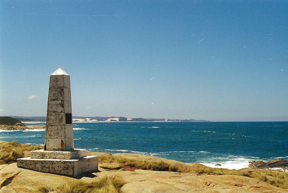
Point Hicks
Grade 4: Today’s Point Hicks is an important historic Landmark which Cook never saw and did not name. Its importance lies in the fact that so much confusion has for so long surrounded what Cook named as Point Hicks. Most people still assume that it is the first place on the Australian coast that Cook saw and named. Its primary importance today is that Cook’s landfall (first sight of real land) on the Australian coast was somewhere to the east of this point. The coast in this area remains remote and unspoiled as part of Croajingolong National Park, and fits perfectly Banks’ description of it at 10 a.m. on the morning of 19 April 1770. A wonderfully wild coast to visit.
Situation: Remote. About 40kms south of the small town of Cann River, Princes Highway, East Gippsland, with some winding dirt road. Pleasant 2km walk to Point Hicks lighthouse from locked gate at end of road at Thurra River. In Croajingolong National Park, see Parks Victoria website for camping, and for accommodation in the Point Hicks lighthouse buildings.
Aboriginal name of today’s Point Hicks: Tolywiarar (Bidhawale and Gunaikurnia peoples)
Coordinates (decimal): 37.80 S 149.28 E (Today’s Point Hicks, formerly Cape Everard, and not what Cook named)
Endeavour Journal, 19 April 1770:
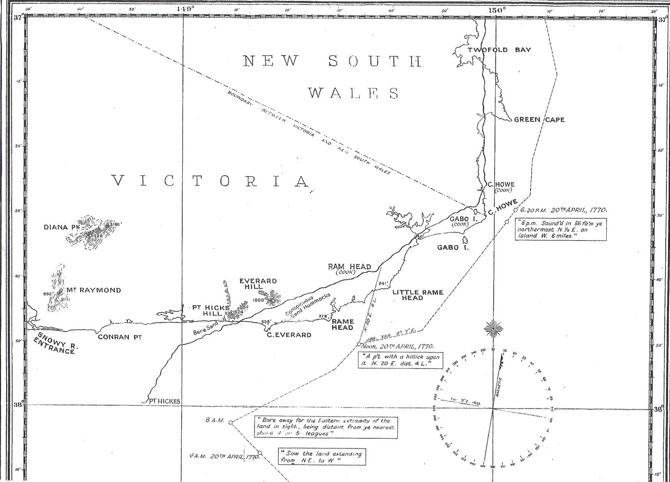
…at 6 [a.m] saw land extending from NE to West at the distance of 5 or 6 Leagues having 80 fathom water a fine sandy bottom. We continued standing to the westward with the wind at SSW until 8 oClock at which time we…made all sail and bore away along shore NE for the Eastermost land we had in sight, being at this time in the Latitude of 37.58 S and Longd of 210.39West. The Southermost Point of land we had in sight which bore from us.
W ¼ S I judged to lay in the latitude of 38.0 S and in the Longitude of 211.7 W from the Meridion of Greenwich. I have named it Point Hicks, because Lt Hicks was the first who discover’d this land. To the Southward of this point we could see no land and yet it was very clear in that quarter…
The correct site of Cook’s Point Hicks has been the subject of controversy since the first European sailors after Cook visited the area. The coordinates Cook gives puts it out to sea and almost due west of his 8 a.m. position (see chart below). Much of the arc of land that Cook records at 6 a.m. was in fact a cloudbank, the furthest southern extent of which he had named as Point Hicks. Cook’s Point Hicks simply does not exist as a land feature. Having experienced a similar illusion in these waters, Matthew Flinders recognised Cook’s error and it does not appear on his charts. Further evidence in support of the cloudbank theory is contained in the 2020 articles listed under References below. However it was widely believed, locally at least, from before 1850 that the nearest land north of Cook’s 8 a.m. position and named as Cape Everard from 1853, was what Cook had seen and named. It was argued that Cook must have made a mistake in stating the coordinates of his Point Hicks. This notion was later picked up by eminent historian Ernest Scott who argued:
There is also some doubt about the exact
locality of Cook's Australian landfall. He named the 'southernmost point of
land we had in sight,’ Point Hicks, because 'Lieutenant Hicks was the first who
discovered this country.’ But unfortunately Cook stated the latitude and
longitude of his Point Hicks incorrectly. He wrote that he 'judged' the point
to be whereas a matter of fact there is no land at all, but only open ocean. We
have therefore to infer what Cook's Point Hicks was from his descriptive words.
The 'southernmost point' in sight of the Endeavour at the time was that which
figures on Admiralty charts as Cape Everard.
Ernest Scott, A Short History of Australia, Oxford, Oxford University Press, 1916
This ignores Cook’s clear statement that his Point Hicks bore W1/4S from his 8 a.m. position, not almost due north. Today’s Point Hicks would indeed have been the southernmost point of real land nearest to Cook’s 8 a.m. position. But, due to the curvature of the earth, it would not have been ‘observable from Cook’s situation’, as he was too far away for this low-lying land to be visible. Further, Cook’s purpose in naming coastal features or landmarks was for the guidance of future navigators. Hence they were prominent and distinctive so as to be readily recognisable from out at sea. Cape Everard does not meet this criterion and so it seems unlikely that Cook would have named it even if he had seen it.
Scott ‘infers’ that Cape Everard was Cook’s Point Hicks. Despite this shaky conclusion, Scott’s eminence convinced other historians and in 1924 a group including Scott persuaded the Federal Government to erect a plaque at Cape Everard claiming that it was Cook’s Point Hicks. The plaque is still there.
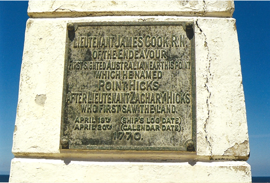
When the bicentenary of Cook’s voyage came around in 1970, despite protests, historians again prevailed and, to commemorate the bicentenary, on 20 April 1970 Sir Henry Bolte, Premier of Victoria, stood on Cape Everard and announced: ‘In 1770 Captain James Cook named the Point on which we stand Point Hicks’.
Since 1907 a number of surveyors/hydrographers (Fowler (1907), Barker (1933), Hilder (1970), Ingleton (1970)) have examined Cook’s log, journal and charts and plotted Endeavour’s track on modern charts and reached the same conclusion as Flinders – Cook’s Point Hicks does not exist as a land feature. Captain Brett Hilder, a very experienced Pacific navigator and hydrographer whose 1970 article provides the most elegant proof of Endeavour’s track near today’s Point Hicks, wrote despairingly: ‘academics tend to believe the printed word of previous scholars rather than the printed charts of practical men who are the real experts in the matter of charting a coastline’
References:
Trevor Lipscombe, Point Hicks – the Clouded Facts, Victorian Historical Journal, Vol.85, No.2, pp232-253, December 2014 https://www.historyvictoria.org.au/wp-content/uploads/2019/09/VHJ-Vol-85-No-2-Dec-2014.pdf
Trevor Lipscombe, Why has the Error of Cook’s Point Hicks Endured? Part 1, Cook’s Log, Journal of the Captain Cook Society, Vol. 43, No. 1, 2020 https://www.captaincooksociety.com/home/detail/why-has-the-error-of-cook-s-point-hicks-endured-part-1
Trevor Lipscombe, Why has the Error of Cook’s Point Hicks Endured? Part 2, Cook’s Log, Journal of the Captain Cook Society, Vol. 43, No. 2, 2020 https://www.captaincooksociety.com/home/detail/why-has-the-error-of-cook-s-point-hicks-endured-part-2
Trevor Lipscombe, Cook’s Point Hicks Revisited, Victorian Historical Journal, Vol.91, No.2, December 2020, pp. 371 – 382
All we can say about today’s Point Hicks (formerly Cape Everard) is that somewhere to its east was Cook’s first landfall on the coast of the Australian continent.