Mount Warning and Point Danger
Grade 5: Today’s Point Danger and Cook’s Point Danger at Fingal Head are both worth visiting to gain an understanding of the long running controversy about its correct location. At the latter you will see the reef that, had Cook arrived an hour or two later, might have terminated his voyage. Mount Warning can be seen at a distance.
Situation: Near Coolangatta and Tweed Heads, border of New South Wales and Queensland
Coordinates (decimal):
Mount Warning: 28.40 S 153.27 E
Fingal Head (Cook’s Point Danger): 28.20 S 153.57 E
Today’s Point Danger: 28.17 S 153.55 E
Cook Island: 28.20 S 153.58 E
Aboriginal name: Wollumbin, sacred place to Bundjalong people, and Cook’s Mount Warning.
Endeavour Journal – 16 May 1770:
Winds southerly a fresh gale with which we steerd North along shore until sun-set at which time we discovered breakers ahead and on our larboard bow, being at this time in 20 fathom water and about 5 Miles from the land. Hauld off east until 8 oClock at which time we had run 8 Miles and had increased our depth of water to 44 fathoms. We than brought too with her head to the Eastward and lay on this tack until 10 oClock when having increased our soundings to 78 fathom we wore and lay with her head in shore until 5 oClock AM when we made sail. At day light we were Surprised in finding our selves farther to the southward than we were in the evening and yet it had blowen strong Southerly all night. We now saw the breakers again within us which we passed at a distance of 1 League, they lay in the Latde of 28.8 and stretch off East two Leagues from a point under which there is a small Island, there situation may always be found by the peaked mountain before mentioned which bears SWbW from them and on this account I have named it Mount Warning. It lies 7 or 8 Leagues inland in the latitude of 28.22 S, the land is high and hilly about it but it is conspicuous enough to be distinguished from every thing else. The point off which these shoals lay I have named Point Danger.
Point Danger:
Given the clear and precise description that Cook gives of the location of Point Danger it is very hard to understand why there has been so much controversy over its location for so long. Cook is sailing smartly along under the influence of a fresh southerly gale. It is sunset, and ahead of him he sees breakers ahead stretching 6 miles out to sea from the land – it is a projection or reef, a serious hazard even though he is currently in 20 fathoms of water and 5 miles offshore. He orders a change of course out to sea to the east as darkness is falling, not at all sure what hazards lie ahead. At 8 p.m. he has sailed a further 8 miles offshore, and is now 13 miles from land. He is relieved to find that the depth of water beneath the ship is now 44 fathoms, and by 10 p.m. it has increased to 78. He is safe for the night. Here he waits until daylight, then finding, despite a southerly gale raging all night, that the ship is further south than the previous evening. He again sees the breakers on the reef between the ship and shore and passes them, going north, at a distance of about 3 miles.
Recognising that the reef represents a considerable hazard to ships as it runs so far off shore at 6 miles, he takes considerable pains to describe its location. He describes the breakers as stretching off 6 miles from a point under which there is a small island. He names this point Point Danger. To confirm this position he gives a bearing for Mount Warning from the breakers. The present Point Danger lies about 5km north from the breakers and from it Mount Warning is on a different bearing. The point Cook describes is today’s Fingal Head (at Tweed Heads, New South Wales), from which Mt Warning is on the bearing that Cook gives. The small island, today’s Cook Island, lies 650m offshore and north east of Fingal Head.
Cook’s description is precise and when in 1823 John Oxley, New South Wales Surveyor General, explored the area he reported Fingal Head as being Cook’s Point Danger. Others, including Phillip Parker King, who stands with Cook and Flinders in the history of Australian coastal charting, have concurred with this view. However, a later exploration caused William Johns, Master of Rainbow, to produce a chart showing Point Danger in its current position, though it is unclear how he reached this conclusion, or why it became the accepted location.
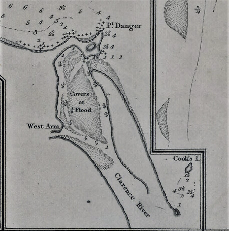
Map showing Danger Reef and Cook’s Island with Point Danger further north in its current position. Three Plans on the east coast of Australia by William Johns, 1831, NLA obj-233819648-1
The case for the existing Point Danger appears to be based on the view that Cook’s ‘small Island’ was not Cook Island but part of the mainland viewed from out at sea, and ‘making like an island’. It is argued that its size on Cook’s chart is too large for it to have been Cook Island. Further, preoccupied by the dangers of the breakers, Cook was focussed on them, so on his approach was not looking in the direction of the land at all (and the land would anyway have been obscured by the setting sun). Cook first observed the land the following morning from the east and north. However, participants in the 1989 re-enactment of Cook’s voyage which followed his course, convinced themselves that Cook Island was what Cook saw. This theory also ignores Cook’s placement of the reef adjacent to his point (not 5km away), and the bearing he gives from the point to Mount Warning.
Despite the evidence, debate has raged and there still appears to be doubt in some minds as to the correct location.
Rupert Gerritsen (see references below) explains:
The reason the designation of Point Danger has posed such a problem and prompted such an enduring, and at times heated, debate is its position on the border of New South Wales and Queensland… it was named as one of the border's defining features in the Letters Patent issued by Queen Victoria in establishing the colony of Queensland in 1859. Consequently, an error in its locational designation is not just a question of an amendment to the names register, it has significant implications, constitutionally and administratively.
This may explain the cautious approach of the New South Wales Geographical Names Register which still describes Point Danger as follows:
Description: |
A rocky point of land extending into the Coral Sea, on the border between New South Wales and Queensland. |
Origin: |
Named by Lt. James Cook - who charted Point Danger on 16.5.1770. The Board acknowledges strong evidence & support for interpretation of Cook's Point Danger being applied to Point Danger or Fingal Head. The passage of time since Cook's voyage and differing opinions precludes a definitive view. |
History: |
Whilst acknowledging 2 accepted origins the Board has resolved that the two landmark names should remain as they are currently named. |
As a result of recent research which was published in Cook’s Log, journal of the international Captain Cook Society early in 2021, the Queensland Places Names authority have finally accepted that today’s Fingal Head is the land feature that Cook named as Point Danger.
Today’s Point Danger is worth a visit. Ironically, it is home to the largest Cook memorial on the coasts of Victoria and New South Wales and a range of bronze plaques cataloguing the debate about the correct location of Point Danger – the Point Danger Lookout and Lighthouse, erected in 1970 to commemorate the Cook bicentenary.
Fingal Head, Cook’s Point Danger, is worth visiting for views of the reef that Cook took such pains to alert future mariners to. Had he arrived in this area an hour or two later, and after nightfall, it might have been where his voyage ended – running into this long projecting reef, a lava flow from the time when Mount Warning was an active volcano. Cook’s Island can also be viewed from the lighthouse while, looking inland, the summit of Mount Warning can just be seen. Take a compass and you will find that it is on the bearing that Cook records.
References:
Rupert Gerritsen, 'A Dangerous Point: Fingal Head and Point Danger', Placenames Australia, June 2013, (online at Placenames Australia website), and 'A Dangerous Question', Map Matters, Issue 16, December 2011.
Trevor Lipscombe, Point Danger, ‘under which there is a small Island’, Cook’s Log, Vol. 44, No. 1 January-March 2021 This article, and correspondence from Queensland Place Names, is reproduced in Map Matters No. 40, Summer – Autumn 2021, pages 10-15:http://www.australiaonthemap.org.au/wp-content/uploads/Map_Matters_40.pdf
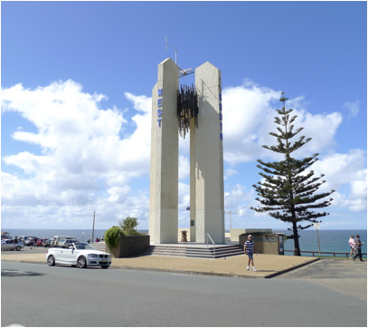
Cook memorial at today’s Point Danger, on the Queensland – New South Wales border
Mount Warning:
This improbably shaped mountain makes a fine Landmark easily recognised from out at sea and suitably named to alert mariners to the reef extending well out to sea at Cook’s Point Danger (today’s Fingal Head). The illustration of Mount Warning below, made at the time probably by Sydney Parkinson, overdramatises it somewhat, but today it still impresses. From the Pacific Highway travelling north or south take the signs to Murwillumbah. Approached from the north, the mountain is the dominant feature, and grows larger and more compelling the nearer you approach. From Murwillumbah follow the signs to Wollumbin National Park, about 16 km along the Kyogle road. The road narrows and steepens dramatically as you approach the car park at the end. From here the return walk to the summit is 8.8 km and takes 5 to 6 hours. It is a long, steep climb and should not be undertaken lightly. The views from the summit on a clear day are extensive and spectacular. Cape Byron with its lighthouse can be seen to the south, and the tower blocks at Tweed Heads guide you to the environs of Point Danger. While many people do still climb Mount Warning the NSW National Parks website offers the following advice: ‘Wollumbin (Mount Warning) summit track is a sacred place to the Bundajalong people. Visitors are asked to respect the wishes of the Bundajalong elders and avoid climbing this very difficult track.’ There are plenty of photos of the view and the mountain online.
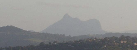
Mount Warning from Tweed River, Coolangatta (en:user:Peter Ellis, uploader to en-wp [GFDL (http://www.gnu.org/copyleft/fdl.html) or CC-BY-SA-3.0 (http://creativecommons.org/licenses/by-sa/3.0/)], via Wikimedia Commons)
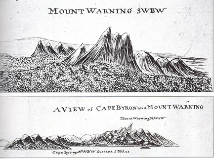
Coastal views of Mount Warning and Cape Byron, Charles Praval, copied from a lost original probably by Sydney Parkinson, May 1770.